
I had already written about the journey beyond Nainital in my article on Kausani . But the first part of the journey from Dehradun to Nainital could not be completed at that time due to paucity of time. Now I have got enough free time to chronicle this first phase as well.
Nainital : a brief introduction
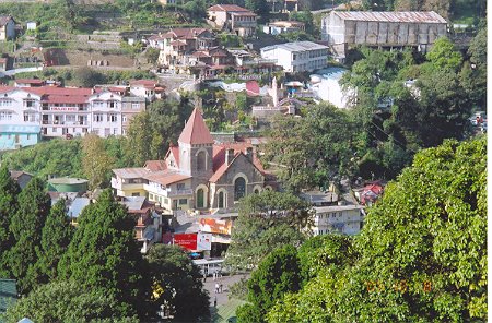
This renowned hill station is one of the most important tourist spot of the Kumaon region of Uttaranchal. Its altitude is 6343 feet (1934 mtr), roughly the same as that of Mussorie (2003 mtr). It has got its name from the Naini lake. Tal in hindi means lake. This emerald green lake is said to resemble the eye of sati, the wife of Shiva. Nainital was once known as Chakta, meaning a city of 60 lakes. But most of the lakes in the area have vanished and only few bigger one remains. The city as of today is the head quarter of the Nainital district. The high court of Uttaranchal is located here. It was an important military station during the Brtitish reign. It was the summer capital of the Government of United Provinces of Agra and Oudh and also the head quarter of the Eastern Military Command. Lord Barron discovered it around 1840. The best time to be here is either in summer or during November.
How to reach there:
There are several ways to reach Nainital. If you are traveling by road from Delhi, then state roadways buses starts from ISBT at Anand Vihar. Always remember to travel by state roadways bus, not by private bus. There are two daily trains to Kathgodam, the nearest railhead. Nainital is just 34 kms from Kathgodam by road. For traveling by train opt for the overnight journey by the 5013 Kathgodam-Ranikhet Express. Similarly, from Dehradun one can travel by the 4320 Kathgodam Express (Wed & Sun) or travel by roadways bus. Traveling by train is always comfortable. But the problem from Dehradun was that the train runs only twice a week and so you would be required to cover one way by road. We had planned a trip to Nainital earlier, but had to discard it for this problem. But this time, we took the tougher option of driving down to Nainital. I was little apprehensive at the beginning about driving 350 km. Well, 350 Km was the estimate I got from people who had drove to Nainital. But it turned out to be much less at 290 km.
The road guide from Dehradun:
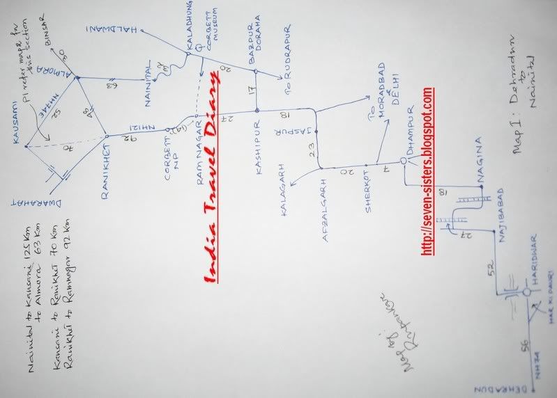
The point to point road distances from Dehradun is as under --
Dehradun 00.0 Km….Start by NH74 for Haridwar. Take the bypass at Haridwar.
Haridwar 56.0 Km….At the gol chakkar turn right over the bridge on Ganga towards
 . But the first part of the journey from Dehradun to Nainital could not be completed at that time due to paucity of time. Now I have got enough free time to chronicle this first phase as well.
Nainital : a brief introduction
This renowned hill station is one of the most important tourist spot of the Kumaon region of Uttaranchal. Its altitude is 6343 feet (1934 mtr), roughly the same as that of Mussorie (2003 mtr). It has got its name from the Naini lake. Tal in hindi means lake. This emerald green lake is said to resemble the eye of sati, the wife of Shiva. Nainital was once known as Chakta, meaning a city of 60 lakes. But most of the lakes in the area have vanished and only few bigger one remains. The city as of today is the head quarter of the Nainital
 district. The high court of Uttaranchal is located here. It was an important military station during the Brtitish reign. It was the summer capital of the Government of United Provinces of Agra and Oudh and also the head quarter of the Eastern Military Command. Lord Barron discovered it around 1840. The best time to be here is either in summer or during November.
How to reach there:
There are several ways to reach Nainital. If you are traveling by road from Delhi, then state roadways buses starts from ISBT at Anand Vihar. Always remember to travel by state roadways bus, not by private bus. There are two daily trains to Kathgodam, the nearest railhead. Nainital is just 34 kms from Kathgodam by road. For traveling by train opt for the overnight journey by the 5013 Kathgodam-Ranikhet Express. Similarly, from Dehradun one can travel by the 4320 Kathgodam Express (Wed & Sun) or travel by roadways bus. Traveling by train is always comfortable. But the problem from Dehradun was that the train runs only twice a week and so you would be required to cover one way by road. We had planned a trip to Nainital earlier, but had to discard it for this problem. But this time, we took the tougher option of driving down to Nainital. I was little apprehensive at the beginning about driving 350 km. Well, 350 Km was the estimate I got from people who had drove to Nainital. But it turned out to be much less at 290 km.
The road guide from Dehradun:
The point to point road distances from Dehradun is as under --
Dehradun 00.0 Km….Start by NH74 for Haridwar. Take the bypass at Haridwar.
Haridwar 56.0 Km….At the gol chakkar turn right over the bridge on Ganga towards
Chandi Devi Temple
Nazibabad 52.0 Km….Turn left at city center. Then turn right to cross a railway crossing.
Nagina 27.0 Km….Before Nagina you will get another rail crossing. Turn left at Nagina.
Dhampur 18.0 Km….Turn left at city center. A few km ahead a road bifurcates towards
Nazibabad 52.0 Km….Turn left at city center. Then turn right to cross a railway crossing.
Nagina 27.0 Km….Before Nagina you will get another rail crossing. Turn left at Nagina.
Dhampur 18.0 Km….Turn left at city center. A few km ahead a road bifurcates towards
Moradabad.
Sherkot 07.0 Km….You may feel like getting out of highway. But keep moving straight.
Afzalgarh 20.0 Km….Turn right where you see a gate. One road goes to Kalagarh
Jaspur 23.0 Km
Kashipur 18.0 Km….Turn right at the point where you see a statue. The straight road
Sherkot 07.0 Km….You may feel like getting out of highway. But keep moving straight.
Afzalgarh 20.0 Km….Turn right where you see a gate. One road goes to Kalagarh
Jaspur 23.0 Km
Kashipur 18.0 Km….Turn right at the point where you see a statue. The straight road
goes to Ramnagar
Bazpur 17.0 Km….Turn left at Bazpur doraha. Here one road goes to Rudrapur
Kaladhungi 20.0 Km….Turn left at the point where Corbett Museum is located. Straight road
Bazpur 17.0 Km….Turn left at Bazpur doraha. Here one road goes to Rudrapur
Kaladhungi 20.0 Km….Turn left at the point where Corbett Museum is located. Straight road
goes to Haldwani
Nainital 32.0 Km….This is the only stretch on the hill. On the way you get to see Khurpa
Nainital 32.0 Km….This is the only stretch on the hill. On the way you get to see Khurpa
tal.
Total distance covered was 290 km. Mail for a detail sketch of road map if you want. (Following few requests I have decided to upload the driving maps here: 1) Map 1 - Dehradun to Nainital and 2) Map 2 - Nainital to Kausani to Ranikhet)
The drive from Dehradun to Nainital :
The drive panned out nicely. Maximum traffic was encountered on the initial stretch between Dehrdaun – Haridwar. Beyond Haridwar, there was hardly any traffic. We had traveled by the Maruti Zen of my cousin brother. Both of us drove in rotation to lessen the load of driving.
We set out at around 9:30 in the morning. Once we had left the crowded stretch of Haridwar, we get into a fairly dense forest area, which probably is an extension of the Rajaji National Park. We stopped at Chiriyapur located within the forest area for a cup of tea. Soon after we got out of the forest area we reached a long bridge under construction. Not knowing what to do, we followed a bus and took the broken road under the bridge. It was a sinking area, with about half feet water at some places. The bus crossed it easily. But we had hard time crossing this stretch as water was deep enough for a small car and the zen got stuck twice on the rocky river bed. Here we could have actually used the bridge. Though it was yet to open to traffic, vehicles were allowed on it. There was a second bridge few kilometers ahead. Here we had no option but to take the road under the bridge as the bridge is yet to be completed. But maneuvering the second sinking area was not that tough as there was not much water. We were told about these bridges and were also told if it rains the night earlier we would not be able to cross this stretches. Fortunately for us, it did not rain the earlier night. We then reached Nazibabad. On the way we got out of Uttaranchal and get into UP. We stopped at a dhaba between Nazibabad and Nagina for lunch. The journey continued through villages, sugarcane fields and small settlements. We traveled through Dhampur, Afzalgarh ans Jaspur to reach Kashipur. (If you are traveling from Delhi via Moradabad, then you can catch this route at Kashipur). Here the road bifurcates. The straight road goes to Ramnagar and Corbett National Park. We took the right turn for Bazpur. On the way we had to pay our second toll of the trip for reason not clearly known. I had written more than once about this abominable practice of toll collection on National Highways in UP and Uttaranchal. We had reached Kaladhungi at around 4 pm. It is located on the foothills of Nainital. The Corbett Museum is located here. Read about it on my article Kausani. In fact, one should not miss it. Tour operators put this on their Corbett itinerary. But I feel it is located too far away from the actual park and should be visited only if one is traveling by this route to Nainital. After the museum visit and a cup of refreshing hot coffee at the nearby stalls, we started the 32 km journey upwards. On the way we got a nice view of the Khurpa tal, but did not bother to go down as it was getting dark. By the time we had finally reached Nainital, it was almost dark. We had to pay toll of 25 bucks one more time for entering Nainital. After asking for guidance here and there, we drove down to the mall road. That concludes the drive from Dehradun to Nainital.
Where to stay:
After reaching the mall road, we were surprised not to find any hotel agent approach us. But once we had stopped before a hotel, several of them appeared from nowhere. We soon found that hotels on the mall quotes very high room tariff. They are in the range of 1500 and above. Even with off-season discounts they were all above thousand. But if you are ready to leave the mall and go a little up, the rates come down to 600 and you will still have lake-facing rooms. We took this wiser option and got nice lake facing rooms at 550 a piece at Hotel Maharaja. The hotel is located on the road to the zoo. It provides free jeep service from the mall to the hotel. Parking space for the car was our worry. Hotel Maharaja boost of a small parking space dug out of the adjoining hill. But one need good skill to park and gets the vehicle out of that spot. So once we had parked, we did not even thought of taking it out until we left Nainital. One thing to remember is that check out time is 10 am. These are the hotel nos I have –
Hotel Maharaja : 05942 – 235281 Mobile: 09897235206 (Room rate –Standard Double : Rs.600/-)
Hotel Lakeside Inn (located on the mall road) : 05942 – 235777 (Room rate –Standard Double: Rs.1450/-)
Local sightseeing at Nainital:
The Naini Lake:
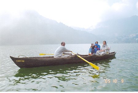
The main attraction of Nainital is the lake and the mall road. A boat ride in the lake is almost unavoidable when in Nainital. Boats in every size and shape are available for an enjoyable ride. You can catch a boat from any of the many boarding points. To make the ride more enjoyable without any effort, we hired a shikara type boat with rowman. So, we did not have to row or pedal for the half an hour ride. Here again you can bargain for rates because there is fierce competition. Boats trips are available for half trip (for covering only half of the lake) or full trip. We enjoyed full trip for Rs.80/- per boat. Most of official website on Nainital will give you a picture of the lake with yacht. However these yacht are available only from boat club and my guess was that they are not available for common public. On the northern end of the lake a temple dedicated to Naina devi is located where it is believed that the eye of sati felled.
The Mall:
The mall road in Nainital is unique. One call strolls on the mall road or can take a man pulled ricksaw. There is an organized system of ricksaws. You need to buy tickets of 5 bucks each for hiring a ricksaw. So, you do not become a victim of fighting of ricksaw pullers. There are few shops on the mall for souvenir shopping. But the main attraction is a bhutia market located on the field next to the lake. This place is called Mallital. What one should look to buy here is designer candles. These candles serve as a good souvenir.
Cave garden:
We had hired a cab for 400 bucks for local sightseeing. The hotels arranged it. This would spare us the headache of driving in an unknown hilly place. The cab took us first to the Cave Garden. To our surprise this spot is located on the road we had traveled from Kaladhungi.
This is a cluster of 5 underground caves. We started with the Tiger Cave. It was the easiest to get in and out. Then we got into the Panther Cave. Getting in and out got harder. I was the only one of our group to get into the third cave named Porcupine Cave. It was the hardest to get in and out. I had to crawl on all four at places inside this cave. I have read that there are 5 caves. But I could found only these three. Here is something to ponder -- just a day before the killer earthquake rocked Kashmir and north India. While going into these underground caves we all forgot about it. I thought about it only after several days.
Himalaya Darshan Point:
The cab then took us to the Himalaya Darshan Point. There is nothing to boast about this spot. But on way to this point you get another point from where the Naini lake looks like a mango. This is the point from where you get a complete view of the lake.
Lovers Point:
The cab then took us to Lovers Point. The view was magnificent from this point. This is the point from where you get horses for going to Tiffin Top. These horses earlier operate from Mallital near the lake. But the horse dung was polluting the lake and beauty of the mall. So the high court had to step in and pushed them this higher. My friend Amit Tripathi who hails from Nainital told me, that there were huge protests, even violent protests, from horse owner when this order was implemented. Here we were given two options by the cab driver --- either come back to this point (which is not possible) or the horses would drop at a point from where the lake is just 5 minutes walk. We had no option but to take the second one. The rate for a horse was 175 bucks for the trip to Tiffin Top and few other spots. It is easy to get fooled by the talk of the horse owner and get to believe that you will be taken to many points. But the truth is that, they will actually take you to two points --- one from where you get a view of the Khurpa Tal and the second is Tiffin Top. All other points are worthless spots that lie on these routes. They would just stop en-route and tell you the name of that spot. We saw people deciding to travel there on foot. Honestly speaking, it would be quite a task to walk to Tiffin Top. But riding a horse on a rocky road was no fun either. All of us were worried and prayed that the horses do not slip. Anyway, I got a nice lesson in horse riding.
Tiffin Top:
After traveling for about half an hour on horse, we reached Tifin Top. With an altitude of 2352 meter (about 7710 feet), it is the second highest point of Nainital. It provides a majestic view of the Nainital town and the lake. What impressed me is the view you get of the thick lush green cover of pine trees down below. There are few tea / snack stalls here. The descend to Mallital started here. The horses dropped us at a point from where the lake was not 5 minutes, but at least 15 minutes walk. One can even think of going to Tiffin Top on foot by this road instead of starting from Lovers Point.
Well, that concludes the local sightseeing. Considering the distances we were actually driven, I felt that the 400 bucks we paid for the cab was a bit high. He hardly drove 15 km. One should try to bargain for 300 bucks. We also enquired about the rate for going to Bhimtal and Naukochiyatal. For this roundtrip of about 70 km, the cab quoted 800 bucks. If you are traveling to Kausani then, try visiting these two lakes en-route. Before concluding, I must make an honest confession that there is not much to see in Nainital. Only point worth seeing is the Cave Garden. Nainital, Khurpatal, Bhimtal, Naukochiyatal and Sattal – all of them are similar looking big lakes with facilities of boating. But after visiting 2 or 3 of them, I bet you will not bother to go to the rest. I am told that the best time to be Nainital is in November when the chinar leaves turn yellow giving a different look to the area. Or, go there during summer, which is the peak season. But to make the trip more interesting one should look forward to go beyond Nainital – to places like Kausani or Binsar.
(Note: The trip was undertaken between 8th to 10th October, 2005)
Total distance covered was 290 km. Mail for a detail sketch of road map if you want. (Following few requests I have decided to upload the driving maps here: 1) Map 1 - Dehradun to Nainital and 2) Map 2 - Nainital to Kausani to Ranikhet)
The drive from Dehradun to Nainital :
The drive panned out nicely. Maximum traffic was encountered on the initial stretch between Dehrdaun – Haridwar. Beyond Haridwar, there was hardly any traffic. We had traveled by the Maruti Zen of my cousin brother. Both of us drove in rotation to lessen the load of driving.
We set out at around 9:30 in the morning. Once we had left the crowded stretch of Haridwar, we get into a fairly dense forest area, which probably is an extension of the Rajaji National Park. We stopped at Chiriyapur located within the forest area for a cup of tea. Soon after we got out of the forest area we reached a long bridge under construction. Not knowing what to do, we followed a bus and took the broken road under the bridge. It was a sinking area, with about half feet water at some places. The bus crossed it easily. But we had hard time crossing this stretch as water was deep enough for a small car and the zen got stuck twice on the rocky river bed. Here we could have actually used the bridge. Though it was yet to open to traffic, vehicles were allowed on it. There was a second bridge few kilometers ahead. Here we had no option but to take the road under the bridge as the bridge is yet to be completed. But maneuvering the second sinking area was not that tough as there was not much water. We were told about these bridges and were also told if it rains the night earlier we would not be able to cross this stretches. Fortunately for us, it did not rain the earlier night. We then reached Nazibabad. On the way we got out of Uttaranchal and get into UP. We stopped at a dhaba between Nazibabad and Nagina for lunch. The journey continued through villages, sugarcane fields and small settlements. We traveled through Dhampur, Afzalgarh ans Jaspur to reach Kashipur. (If you are traveling from Delhi via Moradabad, then you can catch this route at Kashipur). Here the road bifurcates. The straight road goes to Ramnagar and Corbett National Park. We took the right turn for Bazpur. On the way we had to pay our second toll of the trip for reason not clearly known. I had written more than once about this abominable practice of toll collection on National Highways in UP and Uttaranchal. We had reached Kaladhungi at around 4 pm. It is located on the foothills of Nainital. The Corbett Museum is located here. Read about it on my article Kausani. In fact, one should not miss it. Tour operators put this on their Corbett itinerary. But I feel it is located too far away from the actual park and should be visited only if one is traveling by this route to Nainital. After the museum visit and a cup of refreshing hot coffee at the nearby stalls, we started the 32 km journey upwards. On the way we got a nice view of the Khurpa tal, but did not bother to go down as it was getting dark. By the time we had finally reached Nainital, it was almost dark. We had to pay toll of 25 bucks one more time for entering Nainital. After asking for guidance here and there, we drove down to the mall road. That concludes the drive from Dehradun to Nainital.
Where to stay:
After reaching the mall road, we were surprised not to find any hotel agent approach us. But once we had stopped before a hotel, several of them appeared from nowhere. We soon found that hotels on the mall quotes very high room tariff. They are in the range of 1500 and above. Even with off-season discounts they were all above thousand. But if you are ready to leave the mall and go a little up, the rates come down to 600 and you will still have lake-facing rooms. We took this wiser option and got nice lake facing rooms at 550 a piece at Hotel Maharaja. The hotel is located on the road to the zoo. It provides free jeep service from the mall to the hotel. Parking space for the car was our worry. Hotel Maharaja boost of a small parking space dug out of the adjoining hill. But one need good skill to park and gets the vehicle out of that spot. So once we had parked, we did not even thought of taking it out until we left Nainital. One thing to remember is that check out time is 10 am. These are the hotel nos I have –
Hotel Maharaja : 05942 – 235281 Mobile: 09897235206 (Room rate –Standard Double : Rs.600/-)
Hotel Lakeside Inn (located on the mall road) : 05942 – 235777 (Room rate –Standard Double: Rs.1450/-)
Local sightseeing at Nainital:
The Naini Lake:
The main attraction of Nainital is the lake and the mall road. A boat ride in the lake is almost unavoidable when in Nainital. Boats in every size and shape are available for an enjoyable ride. You can catch a boat from any of the many boarding points. To make the ride more enjoyable without any effort, we hired a shikara type boat with rowman. So, we did not have to row or pedal for the half an hour ride. Here again you can bargain for rates because there is fierce competition. Boats trips are available for half trip (for covering only half of the lake) or full trip. We enjoyed full trip for Rs.80/- per boat. Most of official website on Nainital will give you a picture of the lake with yacht. However these yacht are available only from boat club and my guess was that they are not available for common public. On the northern end of the lake a temple dedicated to Naina devi is located where it is believed that the eye of sati felled.
The Mall:
The mall road in Nainital is unique. One call strolls on the mall road or can take a man pulled ricksaw. There is an organized system of ricksaws. You need to buy tickets of 5 bucks each for hiring a ricksaw. So, you do not become a victim of fighting of ricksaw pullers. There are few shops on the mall for souvenir shopping. But the main attraction is a bhutia market located on the field next to the lake. This place is called Mallital. What one should look to buy here is designer candles. These candles serve as a good souvenir.
Cave garden:
We had hired a cab for 400 bucks for local sightseeing. The hotels arranged it. This would spare us the headache of driving in an unknown hilly place. The cab took us first to the Cave Garden. To our surprise this spot is located on the road we had traveled from Kaladhungi.
This is a cluster of 5 underground caves. We started with the Tiger Cave. It was the easiest to get in and out. Then we got into the Panther Cave. Getting in and out got harder. I was the only one of our group to get into the third cave named Porcupine Cave. It was the hardest to get in and out. I had to crawl on all four at places inside this cave. I have read that there are 5 caves. But I could found only these three. Here is something to ponder -- just a day before the killer earthquake rocked Kashmir and north India. While going into these underground caves we all forgot about it. I thought about it only after several days.
Himalaya Darshan Point:
The cab then took us to the Himalaya Darshan Point. There is nothing to boast about this spot. But on way to this point you get another point from where the Naini lake looks like a mango. This is the point from where you get a complete view of the lake.
Lovers Point:
The cab then took us to Lovers Point. The view was magnificent from this point. This is the point from where you get horses for going to Tiffin Top. These horses earlier operate from Mallital near the lake. But the horse dung was polluting the lake and beauty of the mall. So the high court had to step in and pushed them this higher. My friend Amit Tripathi who hails from Nainital told me, that there were huge protests, even violent protests, from horse owner when this order was implemented. Here we were given two options by the cab driver --- either come back to this point (which is not possible) or the horses would drop at a point from where the lake is just 5 minutes walk. We had no option but to take the second one. The rate for a horse was 175 bucks for the trip to Tiffin Top and few other spots. It is easy to get fooled by the talk of the horse owner and get to believe that you will be taken to many points. But the truth is that, they will actually take you to two points --- one from where you get a view of the Khurpa Tal and the second is Tiffin Top. All other points are worthless spots that lie on these routes. They would just stop en-route and tell you the name of that spot. We saw people deciding to travel there on foot. Honestly speaking, it would be quite a task to walk to Tiffin Top. But riding a horse on a rocky road was no fun either. All of us were worried and prayed that the horses do not slip. Anyway, I got a nice lesson in horse riding.
Tiffin Top:
After traveling for about half an hour on horse, we reached Tifin Top. With an altitude of 2352 meter (about 7710 feet), it is the second highest point of Nainital. It provides a majestic view of the Nainital town and the lake. What impressed me is the view you get of the thick lush green cover of pine trees down below. There are few tea / snack stalls here. The descend to Mallital started here. The horses dropped us at a point from where the lake was not 5 minutes, but at least 15 minutes walk. One can even think of going to Tiffin Top on foot by this road instead of starting from Lovers Point.
Well, that concludes the local sightseeing. Considering the distances we were actually driven, I felt that the 400 bucks we paid for the cab was a bit high. He hardly drove 15 km. One should try to bargain for 300 bucks. We also enquired about the rate for going to Bhimtal and Naukochiyatal. For this roundtrip of about 70 km, the cab quoted 800 bucks. If you are traveling to Kausani then, try visiting these two lakes en-route. Before concluding, I must make an honest confession that there is not much to see in Nainital. Only point worth seeing is the Cave Garden. Nainital, Khurpatal, Bhimtal, Naukochiyatal and Sattal – all of them are similar looking big lakes with facilities of boating. But after visiting 2 or 3 of them, I bet you will not bother to go to the rest. I am told that the best time to be Nainital is in November when the chinar leaves turn yellow giving a different look to the area. Or, go there during summer, which is the peak season. But to make the trip more interesting one should look forward to go beyond Nainital – to places like Kausani or Binsar.
(Note: The trip was undertaken between 8th to 10th October, 2005)