
Sinking Tehri : the price of development
Tearful eyes are bidding farewell to the centuries old Tehri town. The gigantic reservoir of the Tehri dam has started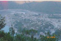 swallowing up the old town. Houses of more than 1 lakh people of Tehri and 112 villages will soon be lost forever. Relocation of the displaced people has been completed though on paper. Harsh reality is that many are yet to get compensation and are fighting a losing battle. The land and houses, however well constructed, up in the hill cannot replace the fertile lands in the valleys. It is never easy for the hill people to leave their houses where generations have lived. Commercial importance of the old town will also probably get shifted to Chamba. The events in Tehri have generated some tourist interest in the last few years. We went to Tehri during last diwali (15th Oct, 2004). It was a memorable journey for me as it was my first outing in Uttaranchal and also the first long drive in the hills. As more and more news of Tehri has started pouring in, it gave an occasion for me to look back and chronicle the trip.
The Drive from Dehradun to Tehri
From Dehradun we proceeded via Rishikesh, Narendranagar and Chamba. There is an alternative route from Dehradun via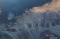 Mussorie and Chamba. But the road via Narendranagar is a better one for a new driver in hills. Once you leave Rishikesh, it is always up the hill. Narendranagar is 16 km from Rishikesh and you can see the Narendranagar Palace on the top of a hill from the Gandhi Chowk in Rishikesh. The palace complex, which was once the abode of the erstwhile King of Garhwal, now houses a five star resort named the Ananda in the Himalayas. There is a bypass at Narendranagar which passes right in-front of this palace. We spent a few minutes at the palace for photography. The guards on duty were polite enough to let us into the complex. The road was quite good and wide as this is used to carry all the heavy equipment and material to Tehri dam site. The sloping of road was also low and my Wagon R with 5 people was pulling well in third gear even in the stiffest stretches. The traffic was sparse as used to be in most hilly roads. A rivulet named Henval flows by the road. We had lunch in a decent roadside restaurant. You will get few of such decent eateries on the route.
Chamba (1524 mtr) was the next big town on the route. It is about 61 km from Rishikesh. The town looked beautiful from distance. Four roads converge at the town center of Chamba. These roads go to Narendranagar (the one we were traveling by), Mussorie, Tehri (and also to Uttarkashi and thus to Gangotri as well) and New Tehri. It has hotels in case you decide to stay. We proceeded straight for going to old Tehri, which that was 17 km away.
Tehri town (Old Tehri)
The final stretch of road was not that good. Near the Tehri bus stand we found a signboard welcoming you to the ‘Emerging tourist spot’ of Tehri, but other than that there is literally nothing to guide you. No road signs. We had to ask here and there and finally reached the point called Dobata from where the road to Uttarkashi starts. It is 70 km to Uttarkashi from here and 166 km to Gangotri. Here we had our first view of the dam and the sinking town down below. We had to take guidance there from the police outpost and started for New Tehri. We were told that no one is allowed to go to the old town. We had to come back to the point where we saw the signboard and took a dusty track that branched off from the main road hoping that this is the right road. After traveling for about 2 km the dusty track joined a blacktopped road. A kilometer or so further, we reached the office of Jaypee Associates who is the company having contract to build all THDC sites including Tehri. We gathered some information from the office there. The road to the dam site starts at this point. One may go to right up to the dam if they can manage prior permission from the THDC. If you know someone in THDC, then it is possible. We went down a few hundred meters by that road to have a good view of the old town and the dam. The town looked deserted and dilapidated. It was not submerged and was waiting its destiny with eerie calmness. Located at an altitude of 755 meters, the old Tehri town is more than two hundred years old. Maharajah Sudarshan Shah established the town as the capital of Tehri-Garhwal in 1803. Sadly, in about a year’s time it will be only in history and photographs.
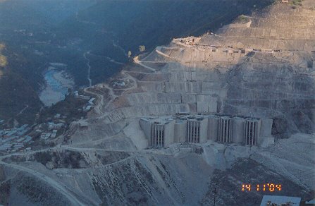
Then we started our journey up to the New Tehri town, which was about 12 km away from this point. On the way up there is a viewpoint (along with a bus shed) at a place called Bhagirathipuram from where you can have a majestic view of the entire dam. I must confess it was quite a site. Dusts from the site had created a grayish layer on the entire site. The bulldozers, the concrete mixers, the trucks – everything down below were looking miniscule and resembled the scene of some sci-fi movie. You could see both the Bhagirathi and Bhilangana rivers from this point. It was late afternoon around 4 pm. The setting sun casted an orange hue to the grey colored concrete surroundings on the higher areas of the dam. The THDC guesthouse is very close to this point. One can also try for accommodation here.
New Tehri
New Tehri town is located at an altitude of 1600 meters. So it was up all the way from old Tehri. Thos stretch of road was not in good shape. Landslides had taken its toll in many places. We finally made it to the New Tehri a few minutes before sunset. We had covered roughly 135 km from Dehradun. New Tehri is a planed town built to rehabilitate residents of Tehri. It has all modern amenities built in a planned way. There are three hotels, all located together very close to the bus stand and the market. These hotels are located on one end of the town, the end that you get while traveling up from old Tehri. It will be opposite end if you travel from Chamba. There also is a GMVN guesthouse just next to the hotels. But we found it closed, may be because of low tourist traffic or to let the hotels survive. We bargained and got good rooms in the first hotel of the row for Rs.250/- a piece. I forgot the name of the hotel. The hotels provide you a magnificent view of a Himalayan peak. The setting sun casted a pinkish orange colour to the peak that was visible from our hotel room. As the sun was setting, the colour changed from pink to orange before becoming white again. I had never seen such a beautiful image of a peak in sunset. I am told that you get o see the best such possible view of this spectacle of colour from Kausani. Unfortunately, I ran out of camera rolls to capture this view and I will always repent this. I still have that scene deeply impregnated in my mind.
Our hotel did not have the restaurant functioning. However it was serving tea. Probably it is same in other hotels as well because all of them appeared to be unoccupied. So we had to go out to the restaurant in the market, which was hardly 50 meters from the hotel. To our shock the shops were closed and the town had gone into sleep even before 7:30. Though it was only mid- October, the cold outside was biting. Fortunately, we had managed to get our dinner in the only restaurant that was open. After returning back to hotel, the cable TV was the only instrument for passing time till the time we went to bed. Thanks to technology that cable TV is now available even in remotest places. We just imagined how would be the life of those getting posted to such remote places, e.g., people working in NHPC can get posted to such places. I must say a posting to Lakwa (in Assam) in ONGC is much better than this.
We started our return journey at around 10 next morning. This time we took a different route and proceeded further up the town and then came down to Chamba. It seems that the main town is located up the road as we get another market in upper areas. Once we left the town, a much larger range of Himalayas started appearing in horizon. We were excited to see a single peak last evening. But here we got a clear view of a large range with many peaks in front of us shining majestically in bright early morning sunlight. Traveling for few kilometers, we got confused in a road junction. There is no road sign. It is very irritating in the hills and is also dangerous. You may not find people for guidance. We almost proceeded by the road that goes to Karnaprayag. But then someone guided us the right way. After traveling for about 11 km from New Tehri we almost made it to Chamba, but got stuck in a traffic jam created by some stupid fellows protesting arrest of Sankaracharya. I really do not understand what is the mindset of such people. They think that by holding up traffic for an hour or so in a nondescript place in the hills they are going to make Jayalalitha listen! Fortunately, by the time we had reached there, half of the scheduled traffic blockade had been completed. So, after about half an hour of hold up, we managed to get out of the jam. Anyway, it gave me some experience of maneuvering a traffic jam in the hills. The incline of the road was very stiff, but fortunately I was driving down. If you keep your engine shut and decides to keep coming down slowly be-aware! Brakes tend to get jammed when your engine is off. But I must conclude that I had thoroughly enjoyed my first driving trip in the hills. When I saw this news pouring on Tehri over last few days, it brings back those beautiful moments.
Where has Ganga gone !
Where has the Ganga gone at Haridwar? Ganga sans Bhagirathi! These are few of the news headlines getting flashed in various news channels in the last few days. The news is that following a court clearance, the tunnel T2 of Tehri dam has been finally closed on 29th Oct, 2005 thereby diverting the water of the sacred Bhagirathi river into the massive 42 sq km reservoir of the dam. Mythology goes that King Bhagirath brought Ganga to earth through penance and so the river is also called Bhagirathi, i.e., river Bhagirathi represents actual Ganga. In fact, Bhagirathi provides 40% of total water supply to Ganga. Following the closure of the tunnel T2, supply of Bhagirathi water has come down to 2 cusec from the normal 1000 cusec. There is an agreement that release of water will be maintained at 40 cusec and the dam officials are claiming that they are maintaining it. Whatever is the amount of water getting released, it is still quite low and imagine how much water will actually reach Devprayag after traversing 80 km. This means that water of Bhagirathi is hardly reaching Ganga and so Ganga has lost its sacredness to the eyes of many who believes that a holy dip will wash away their sins. Alas! Ganga will not do that for them for the next 45 days or so. It is another matter that Ganga is so polluted that you cannot even take a hygienic dip beyond Haridwar. Ganga today is flowing with waters from Alknanda and Mandakini. What is Ganga or even where is Ganga without waters of Bhagirathi? There is considerable resentment over this even in the plains down below. A clash of religious sentiments with technology and development! Yesterday I saw a report in NDTV showing how Bhagirathi has reduced to a stream at Devprayag. I could feel what has actually happened or rather what changes might have taken place in the last few days. I have been to both Devprayag and Tehri in last one year. It was just four months back (23 June, 2005) when we saw the majestic view of the confluence of the two roaring rivers, Alaknanda and Bhagirathi at Devprayag. The river is called Ganga from this point onwards. (You can see this magnificent view of confluence at Devprayag in the Badrinath folder in My Photography)
The Tehri Hydel Project
Why are we undertaking a project that is displacing more than 1 lakh people and is hurting religious sentiments many more lakhs? With a projected generation of 2400 MW electricity, this is one of the largest hydroelectric project in the world. Built at the confluence of Bhagirathi and Bhilangana rivers, the 855 feet tall main dam is the 5th tallest in the world. The main reservoir is a massive 42 sq km that will completely engulf Tehri town along with 40 villages and partially submerge another 72 villages. The project has another 97 feet tall dam 14 km downstream at Koteshwar that will produce 400 MW power of total capacity. This will submerge an additional 16 villages. Besides generating electricity, it will stabilize irrigation to 6 lakh hectre of existing land and will bring another 2.7 lakh hectre under irrigation. It will also provide 270 million gallons of drinking water daily to Delhi, UP and UA. The project was approved in 1972 and construction started in 1978. The Tehri Hydel Development Corporation (THDC) was formed in 1989 to oversee the construction of the project. But it has always mired in controversy and the project got delayed by many years. Even the closing of tunnel T2 that has created the recent controversy was scheduled for Dec 2002. Two lower tunnels T3 and T4 were closed in Dec 2001. Besides the displacement and relocation of more than 1 lakh people, there were environmental concerns as the dam is located in a highly seismic zone. The Uttarkashi earthquake in Oct, 1992 raised further doubts as the dam is just 70 km away from Uttarkashi. One of the noted protestor of the dam is the environmental activist Sundarlal Bahuguna who once undertook a 74 day fast to register his protest. He said once that this dam is built with our tears. One of the major concerns is that what will happen to those living below if this massive dam crashes in an earthquake. Dam officials say it is adequately safe and can withstands earthquakes upto 8.5 Richter. But one should see the programs like “Nature’s Fury” and ‘Nat Geo Investigates” in National Geographic to understand what unexpected things can happen with nature. There already has been an accident on Aug 2, 2004 in one of the tunnel that took few lives as the tunnel gave in following heavy rains.
The dam may be beneficial for development. This is going to take care of all power and water problem of UA, UP and even Delhi. But the residents of Tehri and its adjoining villages had to pay a huge cost. Their struggle will go on and so do the controversies. But with closing of the tunnel T2, the dam is getting ready for generating its first unit of power sometime next year. I wish to visit Tehri again some time next year to see the sunken town.
Tearful eyes are bidding farewell to the centuries old Tehri town. The gigantic reservoir of the Tehri dam has started
 swallowing up the old town. Houses of more than 1 lakh people of Tehri and 112 villages will soon be lost forever. Relocation of the displaced people has been completed though on paper. Harsh reality is that many are yet to get compensation and are fighting a losing battle. The land and houses, however well constructed, up in the hill cannot replace the fertile lands in the valleys. It is never easy for the hill people to leave their houses where generations have lived. Commercial importance of the old town will also probably get shifted to Chamba. The events in Tehri have generated some tourist interest in the last few years. We went to Tehri during last diwali (15th Oct, 2004). It was a memorable journey for me as it was my first outing in Uttaranchal and also the first long drive in the hills. As more and more news of Tehri has started pouring in, it gave an occasion for me to look back and chronicle the trip.
The Drive from Dehradun to Tehri
From Dehradun we proceeded via Rishikesh, Narendranagar and Chamba. There is an alternative route from Dehradun via
 Mussorie and Chamba. But the road via Narendranagar is a better one for a new driver in hills. Once you leave Rishikesh, it is always up the hill. Narendranagar is 16 km from Rishikesh and you can see the Narendranagar Palace on the top of a hill from the Gandhi Chowk in Rishikesh. The palace complex, which was once the abode of the erstwhile King of Garhwal, now houses a five star resort named the Ananda in the Himalayas. There is a bypass at Narendranagar which passes right in-front of this palace. We spent a few minutes at the palace for photography. The guards on duty were polite enough to let us into the complex. The road was quite good and wide as this is used to carry all the heavy equipment and material to Tehri dam site. The sloping of road was also low and my Wagon R with 5 people was pulling well in third gear even in the stiffest stretches. The traffic was sparse as used to be in most hilly roads. A rivulet named Henval flows by the road. We had lunch in a decent roadside restaurant. You will get few of such decent eateries on the route.
Chamba (1524 mtr) was the next big town on the route. It is about 61 km from Rishikesh. The town looked beautiful from distance. Four roads converge at the town center of Chamba. These roads go to Narendranagar (the one we were traveling by), Mussorie, Tehri (and also to Uttarkashi and thus to Gangotri as well) and New Tehri. It has hotels in case you decide to stay. We proceeded straight for going to old Tehri, which that was 17 km away.
Tehri town (Old Tehri)
The final stretch of road was not that good. Near the Tehri bus stand we found a signboard welcoming you to the ‘Emerging tourist spot’ of Tehri, but other than that there is literally nothing to guide you. No road signs. We had to ask here and there and finally reached the point called Dobata from where the road to Uttarkashi starts. It is 70 km to Uttarkashi from here and 166 km to Gangotri. Here we had our first view of the dam and the sinking town down below. We had to take guidance there from the police outpost and started for New Tehri. We were told that no one is allowed to go to the old town. We had to come back to the point where we saw the signboard and took a dusty track that branched off from the main road hoping that this is the right road. After traveling for about 2 km the dusty track joined a blacktopped road. A kilometer or so further, we reached the office of Jaypee Associates who is the company having contract to build all THDC sites including Tehri. We gathered some information from the office there. The road to the dam site starts at this point. One may go to right up to the dam if they can manage prior permission from the THDC. If you know someone in THDC, then it is possible. We went down a few hundred meters by that road to have a good view of the old town and the dam. The town looked deserted and dilapidated. It was not submerged and was waiting its destiny with eerie calmness. Located at an altitude of 755 meters, the old Tehri town is more than two hundred years old. Maharajah Sudarshan Shah established the town as the capital of Tehri-Garhwal in 1803. Sadly, in about a year’s time it will be only in history and photographs.
Then we started our journey up to the New Tehri town, which was about 12 km away from this point. On the way up there is a viewpoint (along with a bus shed) at a place called Bhagirathipuram from where you can have a majestic view of the entire dam. I must confess it was quite a site. Dusts from the site had created a grayish layer on the entire site. The bulldozers, the concrete mixers, the trucks – everything down below were looking miniscule and resembled the scene of some sci-fi movie. You could see both the Bhagirathi and Bhilangana rivers from this point. It was late afternoon around 4 pm. The setting sun casted an orange hue to the grey colored concrete surroundings on the higher areas of the dam. The THDC guesthouse is very close to this point. One can also try for accommodation here.
New Tehri
New Tehri town is located at an altitude of 1600 meters. So it was up all the way from old Tehri. Thos stretch of road was not in good shape. Landslides had taken its toll in many places. We finally made it to the New Tehri a few minutes before sunset. We had covered roughly 135 km from Dehradun. New Tehri is a planed town built to rehabilitate residents of Tehri. It has all modern amenities built in a planned way. There are three hotels, all located together very close to the bus stand and the market. These hotels are located on one end of the town, the end that you get while traveling up from old Tehri. It will be opposite end if you travel from Chamba. There also is a GMVN guesthouse just next to the hotels. But we found it closed, may be because of low tourist traffic or to let the hotels survive. We bargained and got good rooms in the first hotel of the row for Rs.250/- a piece. I forgot the name of the hotel. The hotels provide you a magnificent view of a Himalayan peak. The setting sun casted a pinkish orange colour to the peak that was visible from our hotel room. As the sun was setting, the colour changed from pink to orange before becoming white again. I had never seen such a beautiful image of a peak in sunset. I am told that you get o see the best such possible view of this spectacle of colour from Kausani. Unfortunately, I ran out of camera rolls to capture this view and I will always repent this. I still have that scene deeply impregnated in my mind.
Our hotel did not have the restaurant functioning. However it was serving tea. Probably it is same in other hotels as well because all of them appeared to be unoccupied. So we had to go out to the restaurant in the market, which was hardly 50 meters from the hotel. To our shock the shops were closed and the town had gone into sleep even before 7:30. Though it was only mid- October, the cold outside was biting. Fortunately, we had managed to get our dinner in the only restaurant that was open. After returning back to hotel, the cable TV was the only instrument for passing time till the time we went to bed. Thanks to technology that cable TV is now available even in remotest places. We just imagined how would be the life of those getting posted to such remote places, e.g., people working in NHPC can get posted to such places. I must say a posting to Lakwa (in Assam) in ONGC is much better than this.
We started our return journey at around 10 next morning. This time we took a different route and proceeded further up the town and then came down to Chamba. It seems that the main town is located up the road as we get another market in upper areas. Once we left the town, a much larger range of Himalayas started appearing in horizon. We were excited to see a single peak last evening. But here we got a clear view of a large range with many peaks in front of us shining majestically in bright early morning sunlight. Traveling for few kilometers, we got confused in a road junction. There is no road sign. It is very irritating in the hills and is also dangerous. You may not find people for guidance. We almost proceeded by the road that goes to Karnaprayag. But then someone guided us the right way. After traveling for about 11 km from New Tehri we almost made it to Chamba, but got stuck in a traffic jam created by some stupid fellows protesting arrest of Sankaracharya. I really do not understand what is the mindset of such people. They think that by holding up traffic for an hour or so in a nondescript place in the hills they are going to make Jayalalitha listen! Fortunately, by the time we had reached there, half of the scheduled traffic blockade had been completed. So, after about half an hour of hold up, we managed to get out of the jam. Anyway, it gave me some experience of maneuvering a traffic jam in the hills. The incline of the road was very stiff, but fortunately I was driving down. If you keep your engine shut and decides to keep coming down slowly be-aware! Brakes tend to get jammed when your engine is off. But I must conclude that I had thoroughly enjoyed my first driving trip in the hills. When I saw this news pouring on Tehri over last few days, it brings back those beautiful moments.
Where has Ganga gone !
Where has the Ganga gone at Haridwar? Ganga sans Bhagirathi! These are few of the news headlines getting flashed in various news channels in the last few days. The news is that following a court clearance, the tunnel T2 of Tehri dam has been finally closed on 29th Oct, 2005 thereby diverting the water of the sacred Bhagirathi river into the massive 42 sq km reservoir of the dam. Mythology goes that King Bhagirath brought Ganga to earth through penance and so the river is also called Bhagirathi, i.e., river Bhagirathi represents actual Ganga. In fact, Bhagirathi provides 40% of total water supply to Ganga. Following the closure of the tunnel T2, supply of Bhagirathi water has come down to 2 cusec from the normal 1000 cusec. There is an agreement that release of water will be maintained at 40 cusec and the dam officials are claiming that they are maintaining it. Whatever is the amount of water getting released, it is still quite low and imagine how much water will actually reach Devprayag after traversing 80 km. This means that water of Bhagirathi is hardly reaching Ganga and so Ganga has lost its sacredness to the eyes of many who believes that a holy dip will wash away their sins. Alas! Ganga will not do that for them for the next 45 days or so. It is another matter that Ganga is so polluted that you cannot even take a hygienic dip beyond Haridwar. Ganga today is flowing with waters from Alknanda and Mandakini. What is Ganga or even where is Ganga without waters of Bhagirathi? There is considerable resentment over this even in the plains down below. A clash of religious sentiments with technology and development! Yesterday I saw a report in NDTV showing how Bhagirathi has reduced to a stream at Devprayag. I could feel what has actually happened or rather what changes might have taken place in the last few days. I have been to both Devprayag and Tehri in last one year. It was just four months back (23 June, 2005) when we saw the majestic view of the confluence of the two roaring rivers, Alaknanda and Bhagirathi at Devprayag. The river is called Ganga from this point onwards. (You can see this magnificent view of confluence at Devprayag in the Badrinath folder in My Photography)
The Tehri Hydel Project
Why are we undertaking a project that is displacing more than 1 lakh people and is hurting religious sentiments many more lakhs? With a projected generation of 2400 MW electricity, this is one of the largest hydroelectric project in the world. Built at the confluence of Bhagirathi and Bhilangana rivers, the 855 feet tall main dam is the 5th tallest in the world. The main reservoir is a massive 42 sq km that will completely engulf Tehri town along with 40 villages and partially submerge another 72 villages. The project has another 97 feet tall dam 14 km downstream at Koteshwar that will produce 400 MW power of total capacity. This will submerge an additional 16 villages. Besides generating electricity, it will stabilize irrigation to 6 lakh hectre of existing land and will bring another 2.7 lakh hectre under irrigation. It will also provide 270 million gallons of drinking water daily to Delhi, UP and UA. The project was approved in 1972 and construction started in 1978. The Tehri Hydel Development Corporation (THDC) was formed in 1989 to oversee the construction of the project. But it has always mired in controversy and the project got delayed by many years. Even the closing of tunnel T2 that has created the recent controversy was scheduled for Dec 2002. Two lower tunnels T3 and T4 were closed in Dec 2001. Besides the displacement and relocation of more than 1 lakh people, there were environmental concerns as the dam is located in a highly seismic zone. The Uttarkashi earthquake in Oct, 1992 raised further doubts as the dam is just 70 km away from Uttarkashi. One of the noted protestor of the dam is the environmental activist Sundarlal Bahuguna who once undertook a 74 day fast to register his protest. He said once that this dam is built with our tears. One of the major concerns is that what will happen to those living below if this massive dam crashes in an earthquake. Dam officials say it is adequately safe and can withstands earthquakes upto 8.5 Richter. But one should see the programs like “Nature’s Fury” and ‘Nat Geo Investigates” in National Geographic to understand what unexpected things can happen with nature. There already has been an accident on Aug 2, 2004 in one of the tunnel that took few lives as the tunnel gave in following heavy rains.
The dam may be beneficial for development. This is going to take care of all power and water problem of UA, UP and even Delhi. But the residents of Tehri and its adjoining villages had to pay a huge cost. Their struggle will go on and so do the controversies. But with closing of the tunnel T2, the dam is getting ready for generating its first unit of power sometime next year. I wish to visit Tehri again some time next year to see the sunken town.
10 comments:
thanks for sharing your observations about this sad and controversial project. any more follow-ups appreciated.
Got to your blog from the wikipedia link....a wonderful site and great reads, will be back to read more
hi, really feel great that you travelled a lot in tehri and the adjacent areas. I belong to tehri garhwal and have built a small site, which is Tehri Town and I have also collect some images of tehri dam which can be seen in Tehri Photo gallery . Thanks very much for the information you provided.
Hey
thanks for the info u have posted in the blog.. we are a group of students planning to visit this site, could you provide us with more information regading planning our itenery.
Please contact us at 9971608269..
Thanks in advance.
Please keep posting
Hi,
Got your blog from search engine. You traveled lot and your photos are very good. The information about Tehri is useful. I have visited to Devprayag last year and i was surprised one river is coming with full force and water and other river is coming in calm. Now i found the reason. You said in the article you have Devprayag photo which is taken prior to the construction of Tehri dam. But i could not able to find in your photo gallery. Can you send me the photo to my mail id.
Thank you,
Regards,
B.Baskaran
Dear Mr. Baskaran,
You have not left your email to send the links. Unfortunately these photos were my pre-digital days photos are not in my flickr album. Two shots of Devprayag can be seen at :
http://www.albumtown.com/showalbum.php?uuid=26437&aid=36911&var=1
and
http://www.albumtown.com/showalbum.php?uuid=26437&aid=36911&var=1
Regards.
Rupankar
thanks! i was lukin for som historic info about old tehri but cudnt until i came here....thanks again!
Thanks for sharing nice blog for picnic spot near delhi. There are many near Delhi where we enjoy our weekend holiday with fully adventure activity. You can choose many places for weekend getaways near Delhi.
Thanks for your insightful observation. Recently I visited the location and felt sorry for the old Tehri. I also met some people who, however, have been shifted to the new town but are still struggling to get compensation for their valuable lands that vanished with the entire project.
Thanks for detailed information. I visited the dam site yesterday and liked the beautiful hills. I took the route through Mussourie and I must say Chamba as well as roads are in a bad shape. Small hotels and budget lodges have cropped up without much care for the environment.
Post a Comment