
Badrinath is considered as one of the most pious Hindu tirth. It has special place in Hindu mythology and was a preferred place for doing meditation. My misplaced myth that like most other shrines up in the Himalayas, this shrine is also dedicated to Lord Shiva was evaporated soon after I started Gooogling to know about the place. This is a shrine actually dedicated to Lord Vishnu or Narayan and is referred to as Badrinarayan by the sadhus. However, mythology says that Badrinath (then called Badrikashram) was once abode of Lord Shiva, but was later annexed by Lord Narayan by tricking Lord Shiva to vacate the place. Badri means the tree of berry. It is said that goddess Laxmi assumed the shape of a berry tree to provide Lord Vishnu shade in doing penance here. Badrinath is 343 kms from Dehradun and is located at an altitude of 3123 meters. It is one of the dhams of the char dham circuit in Uttaranchal. Like any of these dhams, a pilgrimage to Badrinath also takes at least 3 days from Dehradun.
(Photographs can be seen at www.albumtown.com/rupankar )
Reaching there:
For a change this time I was not driving and instead had preferred to travel in hired Qualis. Roads up in the hills are normally not that good for driving and are so very tiring. We had a large enough group to fill two Qualis and one Indica. Though not homogeneous and like-minded, we had 17 people to make the group, a real pilgrimage troupe. I found the Qualis an excellent car for hills. It had enough power to pull 8 people up with 50/60 kmph speed. The charges for a Qualis is Rs.6000/- per trip from Dehradun. Indica costs a little lesser at Rs.4500/-. This includes all tolls and parking fee, etc. We had to do a bit of bargaining with 2/3 travel agents to ensure that our cost was the cheapest available. Though the best way to travel to Badrinath is hired cars, there are also regular buses from Haridwar. Do not take package tours; they are very costly.
The route :
Starting from Dehradun, we proceeded via Rishikesh, Byasi, Devprayag, Karnaprayag, Gaucher, Nandaprayag, Chamoli and Pipolkoti, in that order to reach Joshimath. This serves as a kind of transit point for visiting places like Auli (just 5 km via a ropeway), Govindghat (21 km) and Badrinath (44 km). Govindghat again serves as the starting point for going to Hemkund Sahib, the famous Sikh shrine and the Valley of Flowers. As I was not driving, the distances mentioned here would be that of road signs. On day 1, you are expected to cover 300 kms upto Joshimath. On day 2, you visit Badrinath. After performing darshan, we proceeded to Mana village which is just 3 km away. Mana is the last point of Haridwar – Mana highway and is also the last human habitat on this part of the world. One important thing to note is that driving in hills is not allowed after 8 pm. Police will not listen to any plea and you may left stranded on roads. So, decide your night halt before clock ticks 8.
Joshimath to Badrinath:
This stretch of road remains open to traffic only for six months from May to Oct / Nov. It remains snow bound for the rest of the year. The road has gate systems at both ends and opens for one-way traffic only. There are specific timings for opening of gates and so you have to be there on time. The gates open at 6:30, 9:30, 11:30, 14:00 and 16:30. If you have halted at Joshimath, you need to get up at those uncomfortable hours to be ready to catch the 6:30 am gate. As the gates opens at same time from both ends, there is a second gate midway at Pandukeswar where one has to wait to give pass to the traffic from other side. Do not stray or left behind too much from the procession of vehicles, else you may have horrible time giving pass to traffic coming your way. It normally takes about 3 hours to travel this 44 km between Joshimath and Badrinath. The road is terrible, a real nightmare for about 20 kms from Vishnuprayag onwards. It is dusty rock bedded terrain where maintaining road is not possible. You are forced to travel with closed windows. On the way you may get traffic jams at Govindghat. The place bustles with thousands of sikh pilgrims on their way to Hemkund sahib. They arrive here in all forms of vehicles – from two wheelers to trucks, buses and luxury cars. The pilgrims leave behind their vehicles here for 3 days creating irritating traffic headaches.
Accommodation:
There are many hotels in Joshimath to provide you cheap and comfortable accommodation while in Badrinath there are fewer hotels, I saw only two there, one belonging to GMVN. However, there are many dharamsalas where you need your own beddings to avoid discomfort. We had apprehensions that it may be tough to find accommodation during this peak yatra season. But we found accommodation easily at Joshimath. Normal hotel rates are around Rs.500 to 650. Do not dither to bargain. Only place we found fully ocupied was the old GMVN rest house, however accommodation was available at the new GMVN rest house (01389-222226). But we found that none of the rooms has provision for fan. In mid June it was too hot to sleep without a fan and so we had avoided it. There are luxury hotels as well viz. Dronagiri (01389-222221) and Uday Palace (01389-222004) which quoted rates of above thousand for double rooms. Do not bother for TVs as your tired body will ask for sleep and rest.
The journey:
We had started very early in the morning as we had plan to reach Joshimath by 4:30 pm. After a quick stop for breakfast at Byasi, we started the climb up the hill. The beauty around with the gushing white water of the Ganges accompanying on the right side of the road was breathtaking. On the way you get Kaudiyala, a resort known for white water rafting. We had stopped at Devprayag to enjoy the confluence of river Alaknanda and Bhagirathi. These two rivers meet here to assume the name of Ganga from here onwards. We continued along Alaknanda up the hills. On the way we had passed Kirtinagar and crossed Alaknanda for the river to take your left for the first time. Hereafter you would be crossing the river n number of times all along the road for the river to be on your right or left. But the river will keep your company till Badrinath. We found policemen monitoring speed of vehicles at Kirtinagar. The speed limit on the hills is 40 kmph. The driver was smart enough to spot the policemen from distance and slowed down. Next comes Srinagar which is probably the biggest town of the entire road. We had bypassed the Rudraprayag town and had lunch on a small dhaba just outside the town. Out in the hills you cannot be fussy about food. Eat what you get or stay hungry. After passing through Gauchar, Karnaprayag, Nandaprayag, Chamoli and Pipolkoti we finally managed to reach Joshimath at around 6 pm. We were 1 ½ hours behind schedule. As we had missed the last gate, we decided to put up at Joshimath which actually turns out to be a good option. In the evening we went to the Jyortirmath. After almost 12 hours journey, we all had a nice sleep.
We got up early to catch the 6:30 am gate next morning. The queue had around 30 vehicles. From Joshimath we started going down to Vishnuprayag where the Jaypee’s are constructing a hydro project taping the river Alaknanda. Dust track starts here punctuated by good stretches. The road was bad but view was imposing with the river coming down with all its might along the road. After making our way through the traffic at Govindghat, we had to stop at Pandukeswar, the mid point of the road, where there is a second gate for crossing of vehicles from both side. The Adi Badri temple, one of the five Badris is located here. We missed it as we were to travel with the procession. On the way we had stopped to enjoy the site of a glacier feeding Alaknanda. You see several of them on the way. Seeing the river one has to imagine how much water mother earth is producing daily to feed these gushing rivers. Finally we made it to Badrinath after 2 ½ hours.
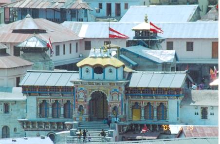
The Badrinath Temple:
The temple complex is beautiful with intricate brightly coloured artwork that resembles mughal style architecture. The King of Garhwal built this modern temple complex in the fifteenth century. Queen Ahilya of Indore donated the golden chatri which is installed in the temple. The Garbhagriha is in its ancient form. The temple is on the Narayan Parvat (mountain) on the southern banks of Alaknanda. The Nar Parvat is located on its opposite. The Nilkanth Parvat with its snow-capped peaks is overlooking the temple providing a magnificent view. The shrine is said to exist here since Satya Yuga when Lord Vishnu mediated at this place. It is said that the original statue was thrown into river Alaknanda to stop it from falling into the hands of Mangolian invaders. Adi Sankaracharya later recovered the statue nearly 2500 years ago by diving into the dangerous Narad Kund on the Alaknanda near the temple. The statue is in the form Shaligram Shila and there is no description of its origin. Adi Sankaracharya also had appointed one of his companions from Nambodiri caste (belonging to Kerala) as head priest. The head priest of this math, called Rawal ji, is still from the same Nambodiri caste. There is a hot water spring called the Tapt Kund, few steps below the temple, which has mentions in Puranas as well and where many pilgrims take bath before darshan. Alternatively, you can take a bath in the icy cold waters of Alaknanda. We had to stand in queue for about 2 hours for darshan of Lord Badrinarayan.
What you should not miss:
Mana Village : This small hamlet is located just 3 km away from Badrinath. A Mongolian tribe inhabits it. It is the last human population on this part of the world. Beyond it you may find stray sadhus trying penance in kaliyug. Here you find a cave called Vyas Ponthi inside which Maharshi Vyas is said to have written the epic Mahabharata. The Saraswati Udgam and Bhim Pool is a magnificent site one should not miss. The mythical river Saraswati is seen emanating from under a mountain with very powerful force before merging into Alaknada just a few meters below. It is said that Saraswati is seen only here and it flows underground to this point. There is a big stone called Bhim Pool lying over the river. Mythology says that the Pandavas went to heaven through this route. Draupadi got scared to cross the Sarswati and so Bhim had placed this stone for her to cross the river. Two km from here lies another mythological fall named Vasudhara. This track leads one to what is known as Swargarohini, the point till which Yudhisthira traveled for going to heaven on foot. It is said that this is the only road where man had ever gone to the heaven on foot. This journey to Satopanth sarovar needs special permission from local authorities. It is very tough 3 days trekking and only a handful can make it.
Reaching there:
For a change this time I was not driving and instead had preferred to travel in hired Qualis. Roads up in the hills are normally not that good for driving and are so very tiring. We had a large enough group to fill two Qualis and one Indica. Though not homogeneous and like-minded, we had 17 people to make the group, a real pilgrimage troupe. I found the Qualis an excellent car for hills. It had enough power to pull 8 people up with 50/60 kmph speed. The charges for a Qualis is Rs.6000/- per trip from Dehradun. Indica costs a little lesser at Rs.4500/-. This includes all tolls and parking fee, etc. We had to do a bit of bargaining with 2/3 travel agents to ensure that our cost was the cheapest available. Though the best way to travel to Badrinath is hired cars, there are also regular buses from Haridwar. Do not take package tours; they are very costly.
The route :
Starting from Dehradun, we proceeded via Rishikesh, Byasi, Devprayag, Karnaprayag, Gaucher, Nandaprayag, Chamoli and Pipolkoti, in that order to reach Joshimath. This serves as a kind of transit point for visiting places like Auli (just 5 km via a ropeway), Govindghat (21 km) and Badrinath (44 km). Govindghat again serves as the starting point for going to Hemkund Sahib, the famous Sikh shrine and the Valley of Flowers. As I was not driving, the distances mentioned here would be that of road signs. On day 1, you are expected to cover 300 kms upto Joshimath. On day 2, you visit Badrinath. After performing darshan, we proceeded to Mana village which is just 3 km away. Mana is the last point of Haridwar – Mana highway and is also the last human habitat on this part of the world. One important thing to note is that driving in hills is not allowed after 8 pm. Police will not listen to any plea and you may left stranded on roads. So, decide your night halt before clock ticks 8.
Joshimath to Badrinath:
This stretch of road remains open to traffic only for six months from May to Oct / Nov. It remains snow bound for the rest of the year. The road has gate systems at both ends and opens for one-way traffic only. There are specific timings for opening of gates and so you have to be there on time. The gates open at 6:30, 9:30, 11:30, 14:00 and 16:30. If you have halted at Joshimath, you need to get up at those uncomfortable hours to be ready to catch the 6:30 am gate. As the gates opens at same time from both ends, there is a second gate midway at Pandukeswar where one has to wait to give pass to the traffic from other side. Do not stray or left behind too much from the procession of vehicles, else you may have horrible time giving pass to traffic coming your way. It normally takes about 3 hours to travel this 44 km between Joshimath and Badrinath. The road is terrible, a real nightmare for about 20 kms from Vishnuprayag onwards. It is dusty rock bedded terrain where maintaining road is not possible. You are forced to travel with closed windows. On the way you may get traffic jams at Govindghat. The place bustles with thousands of sikh pilgrims on their way to Hemkund sahib. They arrive here in all forms of vehicles – from two wheelers to trucks, buses and luxury cars. The pilgrims leave behind their vehicles here for 3 days creating irritating traffic headaches.
Accommodation:
There are many hotels in Joshimath to provide you cheap and comfortable accommodation while in Badrinath there are fewer hotels, I saw only two there, one belonging to GMVN. However, there are many dharamsalas where you need your own beddings to avoid discomfort. We had apprehensions that it may be tough to find accommodation during this peak yatra season. But we found accommodation easily at Joshimath. Normal hotel rates are around Rs.500 to 650. Do not dither to bargain. Only place we found fully ocupied was the old GMVN rest house, however accommodation was available at the new GMVN rest house (01389-222226). But we found that none of the rooms has provision for fan. In mid June it was too hot to sleep without a fan and so we had avoided it. There are luxury hotels as well viz. Dronagiri (01389-222221) and Uday Palace (01389-222004) which quoted rates of above thousand for double rooms. Do not bother for TVs as your tired body will ask for sleep and rest.
The journey:
We had started very early in the morning as we had plan to reach Joshimath by 4:30 pm. After a quick stop for breakfast at Byasi, we started the climb up the hill. The beauty around with the gushing white water of the Ganges accompanying on the right side of the road was breathtaking. On the way you get Kaudiyala, a resort known for white water rafting. We had stopped at Devprayag to enjoy the confluence of river Alaknanda and Bhagirathi. These two rivers meet here to assume the name of Ganga from here onwards. We continued along Alaknanda up the hills. On the way we had passed Kirtinagar and crossed Alaknanda for the river to take your left for the first time. Hereafter you would be crossing the river n number of times all along the road for the river to be on your right or left. But the river will keep your company till Badrinath. We found policemen monitoring speed of vehicles at Kirtinagar. The speed limit on the hills is 40 kmph. The driver was smart enough to spot the policemen from distance and slowed down. Next comes Srinagar which is probably the biggest town of the entire road. We had bypassed the Rudraprayag town and had lunch on a small dhaba just outside the town. Out in the hills you cannot be fussy about food. Eat what you get or stay hungry. After passing through Gauchar, Karnaprayag, Nandaprayag, Chamoli and Pipolkoti we finally managed to reach Joshimath at around 6 pm. We were 1 ½ hours behind schedule. As we had missed the last gate, we decided to put up at Joshimath which actually turns out to be a good option. In the evening we went to the Jyortirmath. After almost 12 hours journey, we all had a nice sleep.
We got up early to catch the 6:30 am gate next morning. The queue had around 30 vehicles. From Joshimath we started going down to Vishnuprayag where the Jaypee’s are constructing a hydro project taping the river Alaknanda. Dust track starts here punctuated by good stretches. The road was bad but view was imposing with the river coming down with all its might along the road. After making our way through the traffic at Govindghat, we had to stop at Pandukeswar, the mid point of the road, where there is a second gate for crossing of vehicles from both side. The Adi Badri temple, one of the five Badris is located here. We missed it as we were to travel with the procession. On the way we had stopped to enjoy the site of a glacier feeding Alaknanda. You see several of them on the way. Seeing the river one has to imagine how much water mother earth is producing daily to feed these gushing rivers. Finally we made it to Badrinath after 2 ½ hours.
The Badrinath Temple:
The temple complex is beautiful with intricate brightly coloured artwork that resembles mughal style architecture. The King of Garhwal built this modern temple complex in the fifteenth century. Queen Ahilya of Indore donated the golden chatri which is installed in the temple. The Garbhagriha is in its ancient form. The temple is on the Narayan Parvat (mountain) on the southern banks of Alaknanda. The Nar Parvat is located on its opposite. The Nilkanth Parvat with its snow-capped peaks is overlooking the temple providing a magnificent view. The shrine is said to exist here since Satya Yuga when Lord Vishnu mediated at this place. It is said that the original statue was thrown into river Alaknanda to stop it from falling into the hands of Mangolian invaders. Adi Sankaracharya later recovered the statue nearly 2500 years ago by diving into the dangerous Narad Kund on the Alaknanda near the temple. The statue is in the form Shaligram Shila and there is no description of its origin. Adi Sankaracharya also had appointed one of his companions from Nambodiri caste (belonging to Kerala) as head priest. The head priest of this math, called Rawal ji, is still from the same Nambodiri caste. There is a hot water spring called the Tapt Kund, few steps below the temple, which has mentions in Puranas as well and where many pilgrims take bath before darshan. Alternatively, you can take a bath in the icy cold waters of Alaknanda. We had to stand in queue for about 2 hours for darshan of Lord Badrinarayan.
What you should not miss:
Mana Village : This small hamlet is located just 3 km away from Badrinath. A Mongolian tribe inhabits it. It is the last human population on this part of the world. Beyond it you may find stray sadhus trying penance in kaliyug. Here you find a cave called Vyas Ponthi inside which Maharshi Vyas is said to have written the epic Mahabharata. The Saraswati Udgam and Bhim Pool is a magnificent site one should not miss. The mythical river Saraswati is seen emanating from under a mountain with very powerful force before merging into Alaknada just a few meters below. It is said that Saraswati is seen only here and it flows underground to this point. There is a big stone called Bhim Pool lying over the river. Mythology says that the Pandavas went to heaven through this route. Draupadi got scared to cross the Sarswati and so Bhim had placed this stone for her to cross the river. Two km from here lies another mythological fall named Vasudhara. This track leads one to what is known as Swargarohini, the point till which Yudhisthira traveled for going to heaven on foot. It is said that this is the only road where man had ever gone to the heaven on foot. This journey to Satopanth sarovar needs special permission from local authorities. It is very tough 3 days trekking and only a handful can make it.
Other important places en-route:
Joshimath (1890 mtr): There is a temple called Jyotirmath. This is the winter seat of Lord Badrinarayan. The idol is broght here during winter when the road to Badrinath is closed. It is one of the four monasteries set up the Adi Sankaracharya, one in each direction to further the cause of Hinduism. Adi Sankaracharya, born as Chandramoulli Shankar in a Kerala village, came to Badrinath at the young age of 11 to perform penance. This was nearly 2500 years ago. The current temple was built in the forties. There is a huge tree called Kalpavriksha, under which Adi Sankaracharya performed penance. Though exact age is not known the tree is proven to be very old. A visit to this tranquil temple complex, located very close to the town centre should not be missed. There is another temple complex known as Narasimha Temple for which we could not find time. The winter ski resort of Auli is connected to Joshimath by a ropeway, which is dubbed as the longest ropeway in Asia. The charge per person per trip to Auli is Rs.300/-. But Auli is worth visiting only during winter.
Govindghat (1828 mtr) : 21 km from Joshimath, this is the transit point for going to Hemkund Sahib and Valley of Flowers. Both the places are around 19 km trekking from here. The trek leads one to Ghangharia, around 15 km away, from where one trek goes to hemkund Sahib and another to Valley of Flowers.
Devprayag : It is one of the panch prayags. Stop here for a while here to enjoy the confluence of Alaknanda and Bhagirathi that gives birth to Ganga.
Rudraprayag : It is also one of the panch prayags. Here you can watch the confluence of Alaknanda and Mandakini.
Pipolkoti : Normally on your way back, you should stay here rather than staying at Joshimath.. This 31 km from Joshimath. If you catch the last gate from Badrinath, you will able to reach here before 8 pm. However, there is no guarantee that the last gate will open exactly at 4:30 pm. We had waited in the queue from 4 pm, but the gate was finally opened at 6 pm. Thus we could made it upto Joshimath only.
(Note : The journey was undertaken from 18th June, 2005 to 20th June, 2005. Non veg food is not allowed beyond Rishikesh. The journey is to be undertaken before moonsoon starts.)
